
Lake life
The Corps and the lake: what Army Engineers mean for Lake Hartwell property owners
When you buy waterfront on Lake Hartwell, you're not just buying a view and a dock. You're buying into a relationship with the U.S. Army Corps of Engineers — the federal agency that built the dam, manages the water level, and controls the shoreline. Understanding that relationship is the difference between a property that works for decades and one that surprises you.
The Corps built the lake. The Corps still runs it.
Lake Hartwell was created between 1955 and 1963 by the U.S. Army Corps of Engineers, Savannah District, as part of the Flood Control Act of 1950. The dam — one of the largest earthen structures in the Southeast — holds back 56,000 acres of water across the Georgia-South Carolina border. But the Corps' role didn't end when the dam was complete. They manage the lake's water level for flood control, hydropower generation, water supply, and recreation. They issue the permits for every dock, every shoreline improvement, and every underbrushing project. They set the rules for what you can build, where you can build it, and how close to the water you can get.
For property owners, this means the lake you see from your porch isn't a static feature of the landscape. It's a managed system. The water level fluctuates — sometimes by a foot, sometimes by seven — based on rainfall, drought conditions, downstream demands, and flood-control requirements. The shoreline changes with the water. And the regulations that govern what you can do with your waterfront are federal, not state or local.
The Shoreline Management Plan: the rules of the water
The Corps manages Lake Hartwell's shoreline through its 2020 Shoreline Management Plan (SMP) — a comprehensive document that divides the lake's nearly 1,000 miles of shoreline into zones, each with specific rules about what can and can't be done. Understanding these zones is essential for anyone considering waterfront property on the lake.
Protected Areas
These are shoreline segments where the Corps has determined that development would be incompatible with environmental, cultural, or scenic values. Private docks are generally prohibited in Protected Areas. Limited private activities — such as fishing or picnicking — may be allowed, but the shoreline remains natural and undeveloped.
Limited Development Areas
These zones permit carefully managed private development — docks, boat ramps, and utility connections — subject to a Shoreline Use Permit (SUP). The Corps reviews each application individually, and permits are granted based on the property's frontage, zoning designation, and compliance with spacing and size requirements.
Shoreline Use Permits
Any structure that extends into the water or modifies the shoreline requires a SUP. This includes docks, walkways, utilities, and even underbrushing — the selective clearing of understory vegetation along the bank. A dock requires at least four feet of water depth at the point where the gangwalk connects, measured at 635 feet elevation. For existing docks, the previous permit number must be provided for review.
The permit process is deliberate. It's not a rubber stamp. The Corps evaluates each application against environmental impact, visual impact, and compliance with the SMP. For property owners, this means planning ahead — a dock isn't something you install on a weekend. It's a federal project that takes time, engineering, and patience.
Why natural shoreline is a feature, not a limitation
Many buyers initially see Corps management as a constraint. You can't build right up to the water. You need permits for improvements. You can't clear-cut the trees along the bank. But for anyone who understands waterfront real estate, these constraints are precisely what protect your investment.
On a privately managed lake, shoreline development is limited only by what the market will bear. The result is often a wall of docks, retaining walls, and cleared lots that strip the natural character of the waterfront. The view from the water becomes a parade of real estate rather than a landscape. Property values fluctuate with the degree of development around you — and you have no control over what your neighbor does next door.
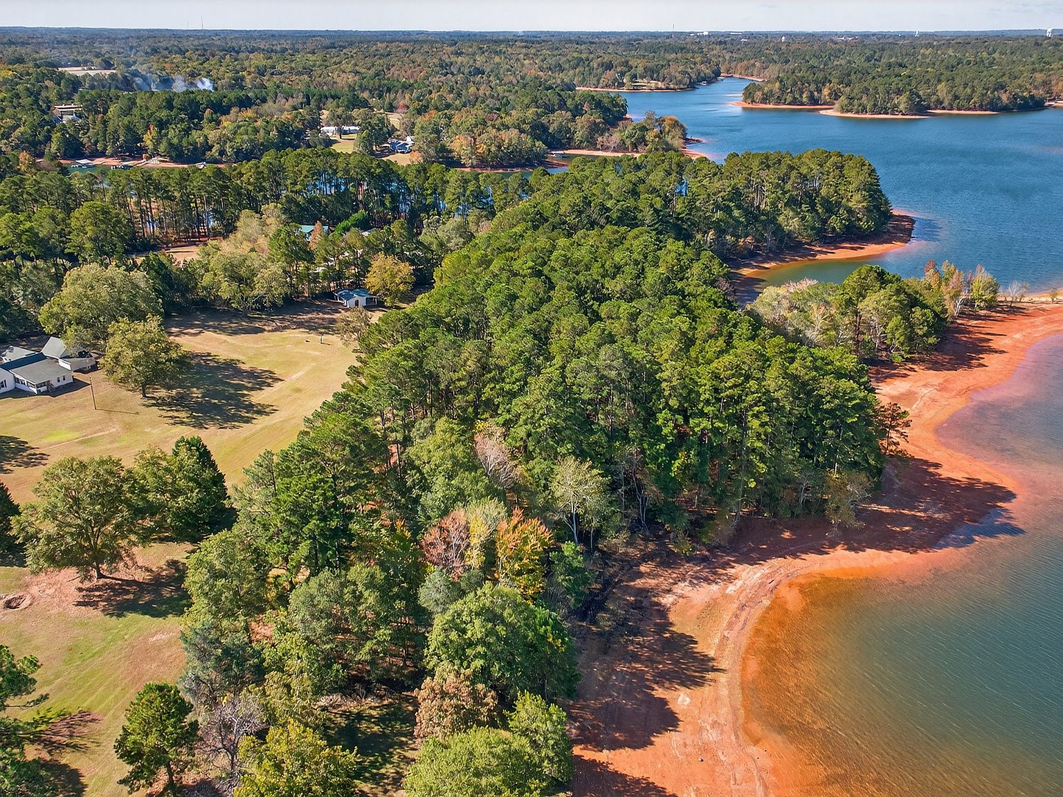
Lake Hartwell's Corps management prevents this. The natural, undeveloped shoreline — wooded banks, clean water, the kind of cove where you can tie up a boat and not see another dock for a quarter mile — isn't an accident. It's a policy. The Corps protects the scenic and environmental integrity of the shoreline as part of its mandate, and that protection applies equally to every property on the lake.
The practical effect is significant. Properties on Corps-managed shoreline maintain their view corridors, their privacy, and their relationship to the natural landscape. The water stays clean because the shoreline stays vegetated. The banks hold because the root systems hold. And the aesthetic experience — standing on your lawn and looking across the water at trees instead of condos — remains consistent regardless of what happens to the real estate market.
What the water level means for your property
The Corps manages Lake Hartwell's water level within a defined operating range. Full pool is 660 feet above mean sea level. In drought years — like 2025 and 2026, when the lake has sat seven or more feet below that target — the water retreats enough to change how the lake looks and functions. Docks that normally sit in deep water can end up in mudflats. Boat ramps that work at full pool may not reach the water.
This is where property elevation matters. 257 Methodist Park Lane sits on land that was above the full-pool line before the dam was built — the same reason the property survived the lake's creation in the first place. The flat lawn, the pavilion, the covered porch, and the pecan grove all sit well above the waterline. The property functions at any water level because it was designed for the land, not the water.
Properties with low-elevation shorelines — docks engineered for full pool, boat ramps graded for a specific water level — experience drought as a practical crisis. Properties with higher elevation experience it as a visual change and a curiosity. The difference is structural, not cosmetic, and it's the kind of advantage that only reveals itself over time.
The 2026 water supply study and the future of the lake
In October 2025, the Corps released a Draft Hartwell Lake Integrated Water Supply Storage Reallocation Report, studying how water supply demands may change in the decades ahead. The report examines whether the lake's water should be reallocated among its primary purposes — flood control, hydropower, navigation, water supply, and recreation — as regional growth increases demand.
For property owners, this study signals something important: the Corps is actively managing the lake's future, not just maintaining its past. Water supply is increasingly important across the Southeast as populations grow and climate patterns shift. The study's findings will influence how the Corps manages water levels in coming decades — and that, in turn, affects the experience of owning waterfront.
Properties that work across a range of water levels — properties built on high ground, with natural shoreline and resilient infrastructure — are best positioned for whatever management decisions emerge. 257 Methodist Park Lane, with its elevation above full pool, its Corps-managed natural shoreline, and its century-and-a-half track record of adapting to change, is precisely that kind of property.
Living with the Corps: what it means in practice
For most property owners, the Corps' presence is felt in three practical ways: the water level, the shoreline, and the permits. The water level is out of your control — it's managed by the Corps based on basin-wide conditions, and you adapt to it. The shoreline is protected — you can maintain and selectively clear it, but you can't fundamentally alter its character. And the permits take time — a dock or shoreline improvement is a months-long process, not a weekend project.
These constraints shape the Lake Hartwell lifestyle in ways that are ultimately positive. The natural shoreline keeps the water clean and the views intact. The managed water level prevents the extreme fluctuations that damage properties on unmanaged lakes. And the permit process ensures that new development is compatible with the lake's character rather than driving its transformation.
At 257 Methodist Park Lane, the Corps' management aligns perfectly with the property's existing character. The shoreline is already natural and undeveloped — wooded banks, clean water, the kind of setting that the SMP was designed to protect. The property sits above the flood line, so water-level fluctuations are visual, not functional. And the improvements that matter — the pavilion, the porch, the lawn — are all on land, above the Corps' jurisdiction, designed for the life that happens outside the water's edge.
The Corps built the lake. The Corps manages the lake. And for the right property, the Corps' management is the reason the lake stays beautiful, the shoreline stays natural, and the investment holds its value. Understanding that relationship is the first step to owning waterfront on Lake Hartwell with confidence.