
Heritage
What low water reveals: Lake Hartwell’s 2026 drought and the history beneath
In the summer of 2026, Lake Hartwell sits more than seven feet below full pool. The U.S. Army Corps of Engineers has declared two successive drought trigger levels since September 2024, and the water has responded accordingly — pulling back from the shoreline, exposing wide bands of red clay, and revealing things that normally stay buried beneath 56,000 acres of reservoir. For the lake community, it's a disruption. For anyone who knows the history of this land, it's a reminder.
What the numbers say
Full pool on Lake Hartwell is 660 feet above mean sea level — a number that represents the water level the Corps of Engineers targets for the lake to function as designed: recreation, flood control, hydropower, and water supply all calibrated to that line. In April 2026, the lake was measured at approximately 652.7 feet — more than seven feet below that target. For context, each foot of elevation on Lake Hartwell represents roughly 3,000 to 4,000 acres of exposed shoreline, depending on the slope of the banks. At seven feet below full pool, the lake has retreated enough to fundamentally change how it looks and how people use it.
The causes are straightforward: extended drought conditions across the Savannah River basin, below-average rainfall through the winter and spring of 2025–2026, and higher-than-normal summer evaporation. The Corps manages the lake as part of the broader Savannah River system — Hartwell, Russell, and Thurmond lakes work in sequence — so the drawdown affects all three reservoirs. In December 2025, the upper Savannah River reservoirs entered Drought Trigger Level 1. By mid-2026, the conversation had moved to practical concerns: shallow water hazards for boaters, restricted marina access, and the economic ripple effects on a lake community that depends on the water being full and usable.
What emerges when the water recedes
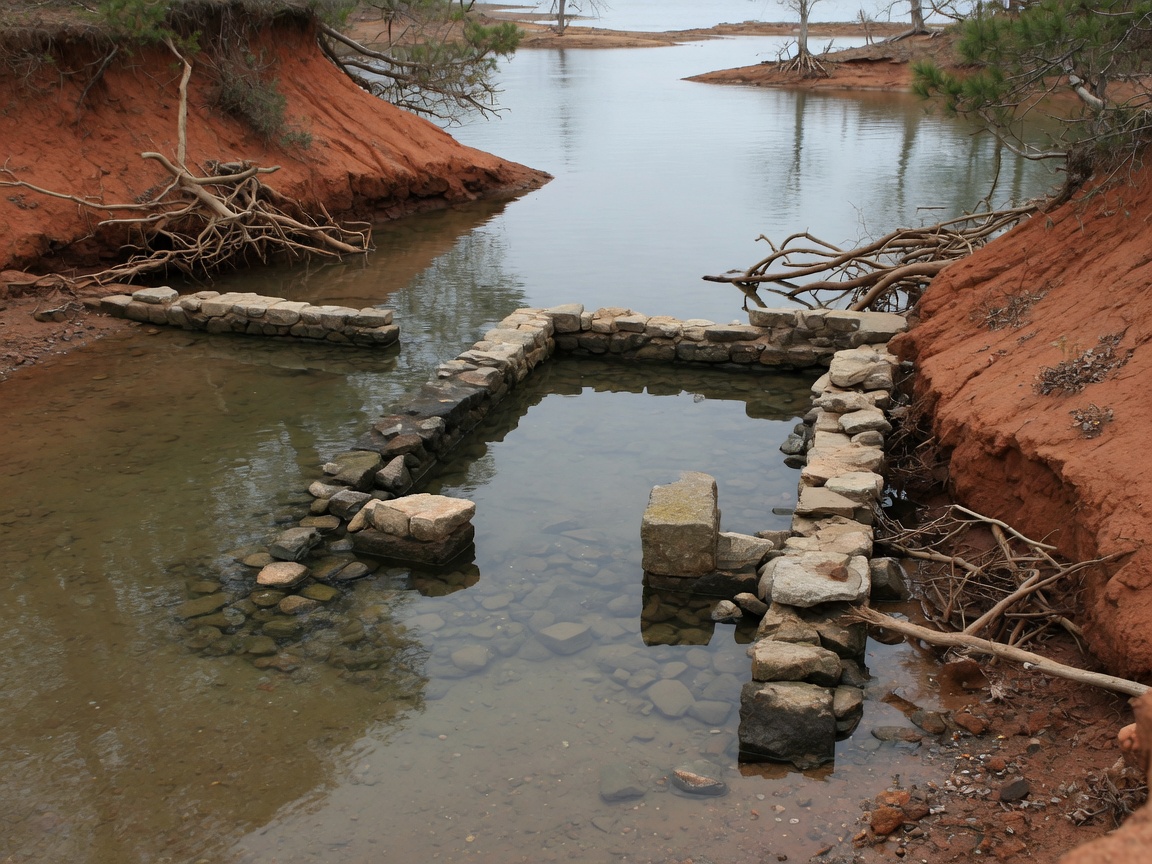
When a man-made lake drops below its normal operating range, the landscape it replaced reasserts itself. Lake Hartwell is no exception. At seven feet below full pool, families report seeing old road beds, fence lines, and stone foundations that haven't been visible in years — sometimes decades. The ghost towns that the Corps submerged during the lake's creation between 1955 and 1963 — communities like Andersonville, South Carolina, and the dozens of family homesteads along the original Savannah, Seneca, and Tugaloo river valleys — are closer to the surface than they've been since the dam was completed.
Boaters navigating the coves near Elrod Ferry Landing have reported encountering shallow rock formations and old pilings that don't appear on any current chart. The Corps has issued multiple safety warnings throughout the summer, urging caution on the water due to submerged hazards made newly dangerous by the lower water levels — obstacles that boats passed over without issue at full pool now sit just below the surface, posing real risk to hulls and propellers.
The history this property survived
This is where the story of 257 Methodist Park Lane intersects with the drought in a way that matters for anyone considering ownership. When the Corps of Engineers authorized the Hartwell Dam project through the Flood Control Act of 1950, the resulting reservoir inundated nearly 2,000 families' properties. Homes, barns, bridges, churches, and family cemeteries were submerged as the water rose year by year between 1955 and 1963. Entire communities — Andersonville, Portersville, and dozens of unnamed homesteads — simply disappeared beneath the rising lake.
257 Methodist Park Lane didn't disappear. The property sits on 4.546 acres of flat, private land at an elevation above the full-pool line — high enough to avoid inundation when the lake was created, and high enough to remain well above water even in a severe drought. The home, built in 1873, was already standing for 82 years when the dam project began. The family held the property through the displacement, through the rising water, and through the transformation of their river valley into a reservoir. The same flat ground, the same mature pecan trees, the same orientation toward the water — all of it survived because someone built wisely on land they intended to keep.
In a year when the lake is seven feet below full pool and properties with low-lying shorelines are struggling with exposed mudflats, restricted dock access, and navigation hazards, that elevation matters. It's not just a historical footnote. It's a practical advantage — the kind that reveals itself every time the water does what water does: rise and fall.
What the drought means for lakefront property
The 2026 drought has created a natural experiment in lakefront real estate. Properties with low-elevation shorelines — docks that now sit in mud, boat ramps that don't reach water, access roads that were designed for full-pool conditions — are discovering the practical limits of their locations. Properties with higher elevation and natural, undeveloped shoreline are experiencing the drought as a curiosity rather than a crisis.
At 257 Methodist Park Lane, the shoreline is managed by the Corps of Engineers and remains wooded, natural, and undeveloped — a condition that protects the bank from erosion during both high and low water. The flat lawn sits well above the waterline, so the dock and water access are unaffected by a seven-foot drawdown. The pecan trees, the pavilion, the covered porch — none of these depend on the lake being at full pool. The property functions at any water level because it was designed for the land, not the water.
That distinction matters. A lakefront property designed around a specific water level is a property at risk — because the water level is not a constant. Lake Hartwell is managed by the Corps for multiple purposes, and the water level fluctuates based on rainfall, drought, downstream demands, and flood-control requirements. A property that works at 660 feet but doesn't work at 653 feet is a property that will have problems for years. A property that works at any water level is a property built to last.
The long view
Lake Hartwell will recover. The drought will break, the water will rise, and by next summer the lake will be back to its normal operating range — full enough for recreation, boating, and the full complement of lake activities that define life on the water. The Corps has managed these cycles since 1962, and the infrastructure is designed to handle both extremes.
But the 2026 drought is a useful reminder of what lies beneath — and what sits above. Beneath the water are the remnants of a world that was displaced to create the lake. Above the water, on the high ground that was never submerged, sit the properties that survived: the farms, the homesteads, and the estates that were here before the dam and remain here now. 257 Methodist Park Lane is one of the last remaining large-acreage parcels on Lake Hartwell's Georgia Corps of Engineers shoreline, and its position — on land that has never been at risk from the water, elevated above the flood line since before the lake existed — is the reason it has survived for over 150 years.
When you own this property, you don't worry about drought levels. You don't check the Corps' daily pool reports. You don't wonder whether your dock will reach the water. The lake is there — beautiful, challenging, variable — and the land is yours regardless. That's not a luxury feature. It's the fundamental advantage of a property that was built on the right ground by people who understood what the land needed.